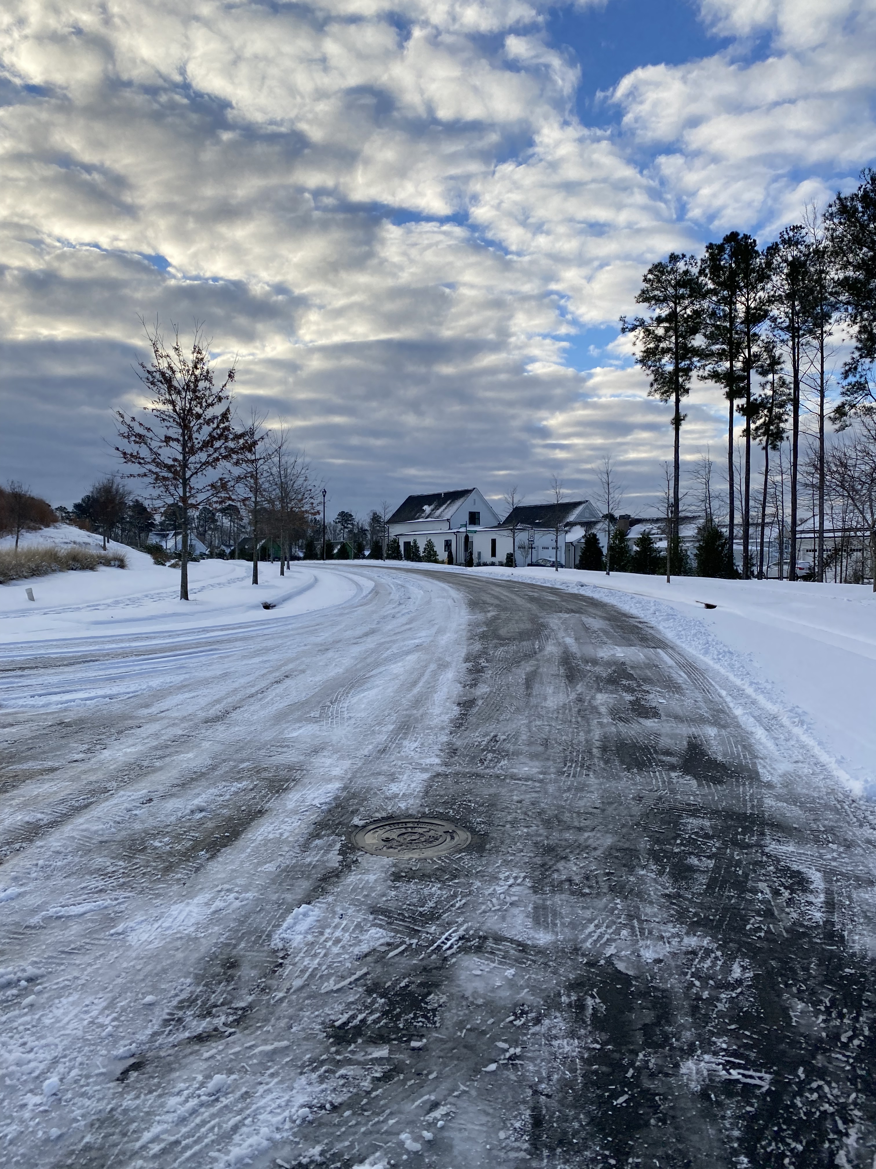
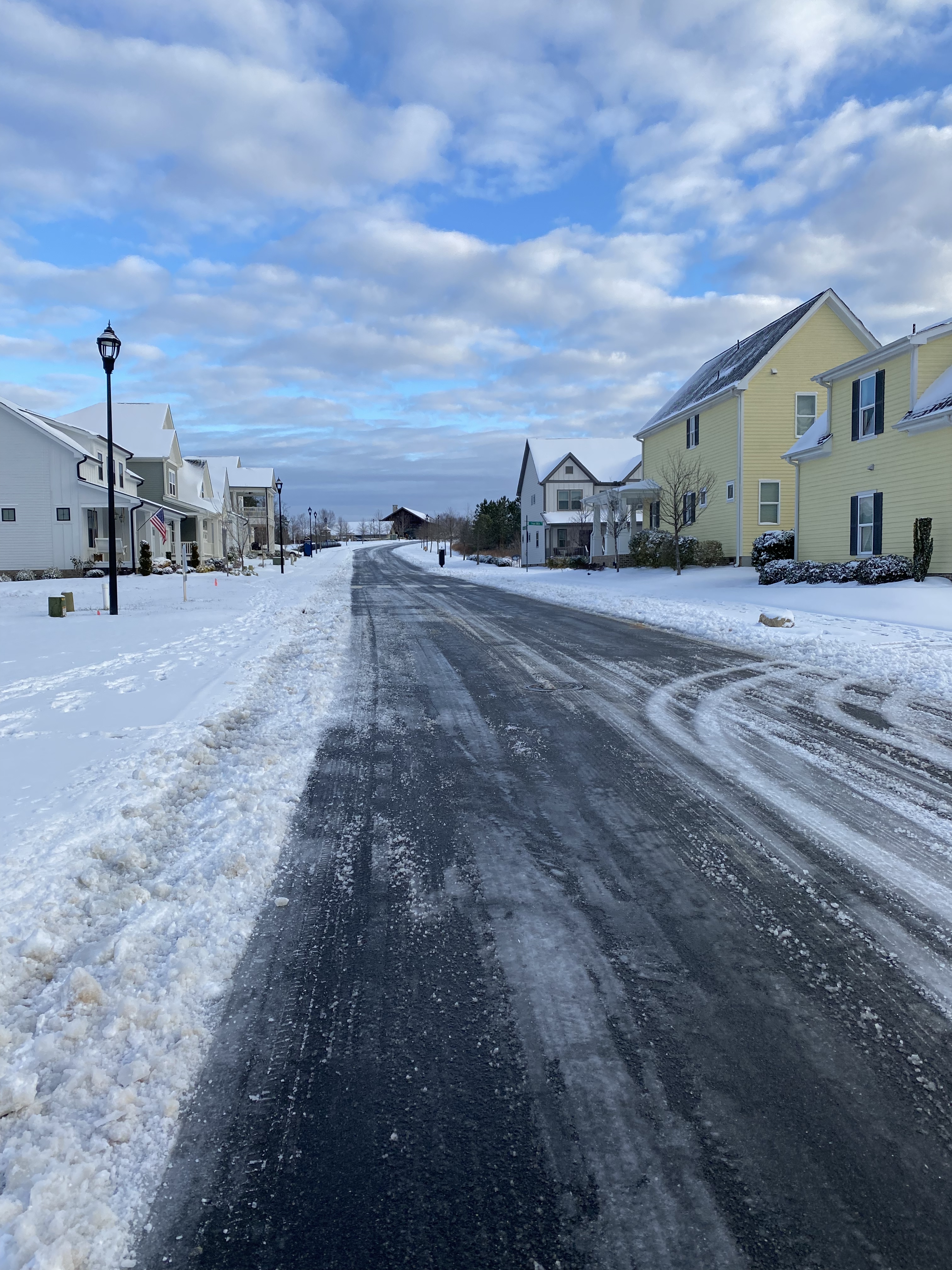
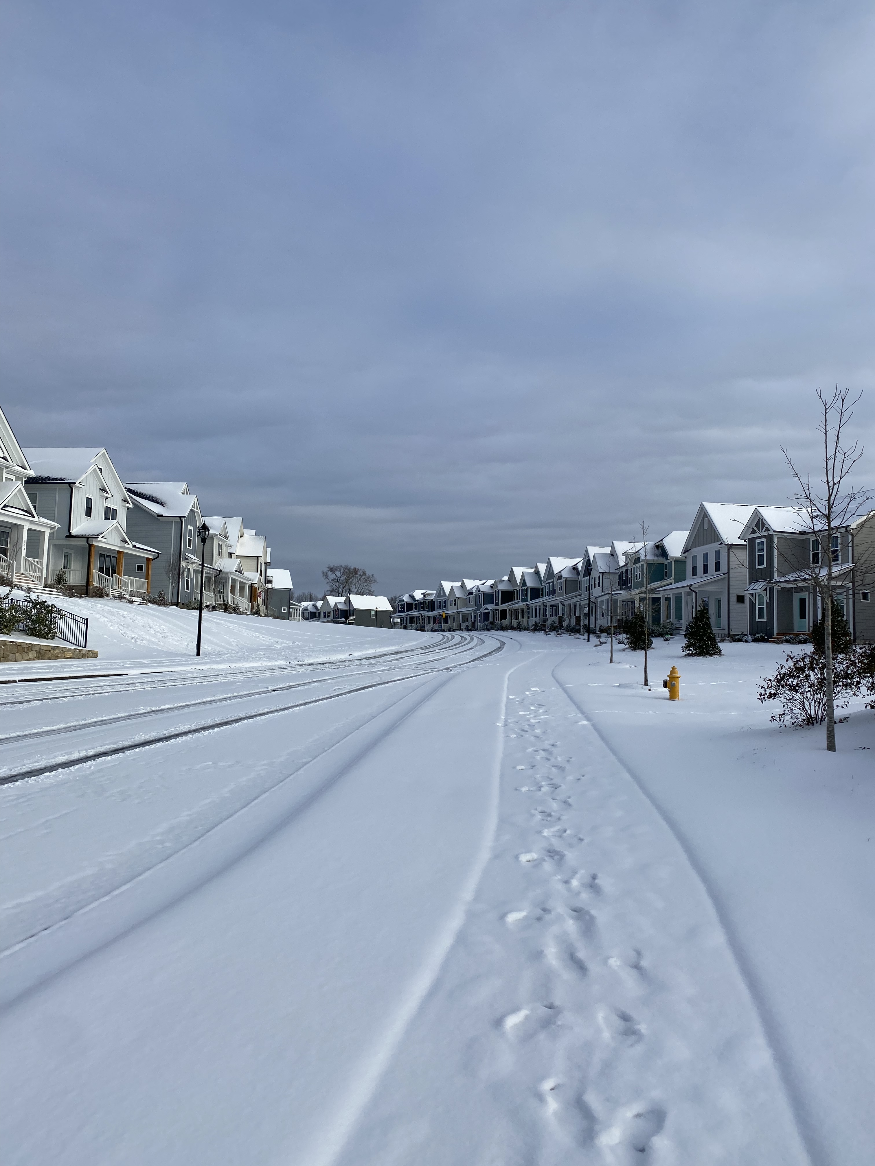
The Wendell Falls community is expected to have more than 4000 residences and 2,000,000 square feet of commercial once completed. One of the major issues facing the neighborhood currently is the speed on some of the residential streets. I believe this is due to the vast width of some of the streets. Big Falls Drive for example is over 30′ wide in sections.
A countermeasure to the speeding would be to add 4-way stop signs – which the town is working on – as well as the addition of bike lanes.
Wider road lanes give the illusion of being wide and open which induce higher speeds. Bringing the lanes down to 10′ or 11′ by restriping for bike lanes will encourage lower speeds, providing safe access for biking, scootering, and even golf carting to and from the commercial sections of the neighborhood.
Take a detailed, interactive look at the plan by clicking on the GoogleMap below.
Add Striped Bike Lanes to Big Falls Drive from Publix to Encore
Add Striped Bike Lanes on Elk Falls Drive – Coordination / compromise may be needed South of Lake Myra Elementary
Add Striped Bike Lanes on the duration of Taylor Road – Coordination / compromise may be needed around the Wendell Falls Pkwy light. Sharrows may be needed East of Daniel Ridge Road.
Add a sidewalk to Taylor Road East of the limits of Wendell Falls – I believe the Town may have a plan in place.
Add a sidewalk to Poole Rd / Martin Pond Road within the limits of Wendell Falls – The town and developers are planning this.
Add 4-way stops to Big Falls at Mallard Trace, Liberty Star, and Taylor Road, Daniel Ridge Road at Iron Mill Road, and Mill Station at Mallard Trace. – The town is working on analyzing 4-way stops.
There is one primary route in and out of Downtown Raleigh to the North. That being Capital Blvd. The three mile stretch of Capital Blvd from Peace Street to I-440 is a 45 MPH divided facility with some limited access characteristics. There are some parts that are near freeway standards, but also some stretches with curb cuts and stop lights. For example, there are full interchanges at Wade Ave, Wake Forest Rd, and I-440 but signals at Hodge Rd and Crabtree Blvd.
The land use is almost completely industrial and while there are developments taking shape in the surrounding areas, Capital Blvd itself has no plans. There are also no bike or pedestrian accommodations.
Volumes as estimated from NCDOT range from 55,000 North of Peace St, to 32,000 South of I-440.
Proposal:
My proposal would include converting Capital Blvd to expressway standards from Peace St to I-440, extend West St from it’s current terminus to Hodges St, extend Halifax St to Wake Forest Rd, construct a grid system on either side of Capital Blvd, and constructing a network of Greenways connecting Downtown Raleigh directly to the Iron Works District and Crabtree Creek Greenway.
The Capital Blvd improvements would include upgrading the existing interchanges, shoulders, and intersections to expressway standards. While the real benefits will be realized by the new connections detailed below, doing this would increase safety and decrease confusion of the hybrid model it currently is today. While it is technically an upgrade, no widening would be involved and in a lot of cases, the roadway width would decrease. As Downtown Raleigh rapidly grows, this would create a reliable route in and out of town while ensuring other routes do not become clogged. Explore the conceptual plans below.
Exits would be provided at Wade Ave, Wake Forest Rd, and Hodges St / Six Forks Rd Extension.
New Connections
Extending West Street from it’s current terminus up to Hodges Street would open up a world of opportunity for this stretch North of Raleigh.
Currently West St ends near Wade Ave leaving drivers to only use Capital Blvd. As mentioned earlier, this has stymied development in the area since Capital Blvd is a six lane, 45 MPH facility.
Extending West St just West of Capital Blvd as a two lane facility with buffered bike lanes would allow for current underused industrial facilities to be repurposed as mixed use hubs. This will create a seamless connection between Midtown, the Iron Works District and the North end of Downtown Raleigh that isn’t feasible with Capital Blvd.
Just North of Wake Forest Rd, Capital Blvd currently splits directionally. Pushing the alignment to both directions being near the current NB direction opens up several blocks worth of prime development space along the new West St.
Halifax Street currently ends as it approaches the rail yard. Extending it over the rail yard and then parallel to Capital Blvd to Wake Forest Rd would achieve similar benefits as the West St extension.
To further connect and create neighborhoods that are currently cut off by Capital Blvd, I’m proposing three new connections over Capital Blvd between West and Halifax Streets.
The Fairview Road extension would eliminate the current ramp to and from Capital Blvd, which is a desire by the neighborhood. It would also connect it to the Mordecai district via Halifax Street Extension. Vehicles still wishing to access Capital Blvd can do so using Wade Ave or it’s extension.
The Blount Street and Gavin Street extension continues the theme of connecting the two neighborhoods while still preventing access directly to and from Capital Blvd.
The Automotive Way Extension serves as a frontage road on the East side of Capital Blvd North of Wake Forest Road again providing opportunity to transform a sleepy industrial corridor.
The Whitaker Mill Road Extension services a booming development area, connecting it directly to Capital Blvd through the West Street and Automotive Way Extensions making the area feel more connected to the grid.
The Six Forks Road / Crabtree Blvd Extension provides a direct connection between Midtown and Wake Med. Doing so transforms a series of road stubs into a cohesive corridor and opens up a whole new level of connectivity in this quadrant of town.
Greenways
My proposal would construct a Greenway along Pigeon Branch Creek from future Deveraux Meadows Park in Downtown to Crabtree Creek.
For a more direct connection to the Iron Works District an additional Greenway should be constructed along West Street North of Wake Forest Road and along Whitaker Mill Road.
The addition of these Greenways would create a comprehensive off road network getting in and out of Downtown Raleigh. When paired with the Atlantic Ave bike lanes and Crabtree Creek Greenway, Downtown is connected with Midtown, points West and points East creating a complete network.
I believe connectivity is the one thing holding Raleigh back currently. Creating cities that are cohesive, connected, and accessible for all is my goal.
This plan would go a long way in achieving those three goals. It stitches neighborhoods together while also allowing for more dense in-town development on what is currently underused land, create a dedicated and safe bike network in and out of Downtown, all while creating a safer, more reliable Capital Blvd.
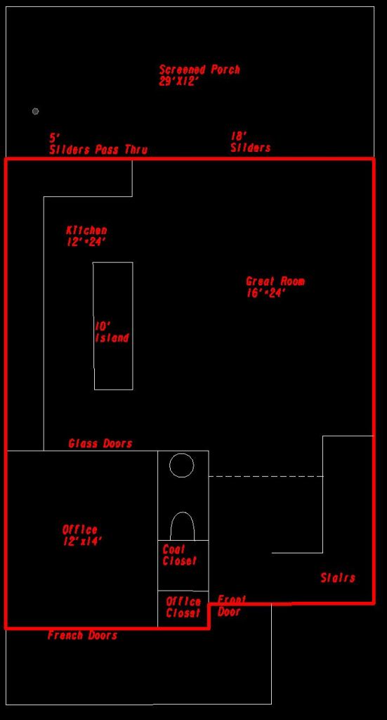
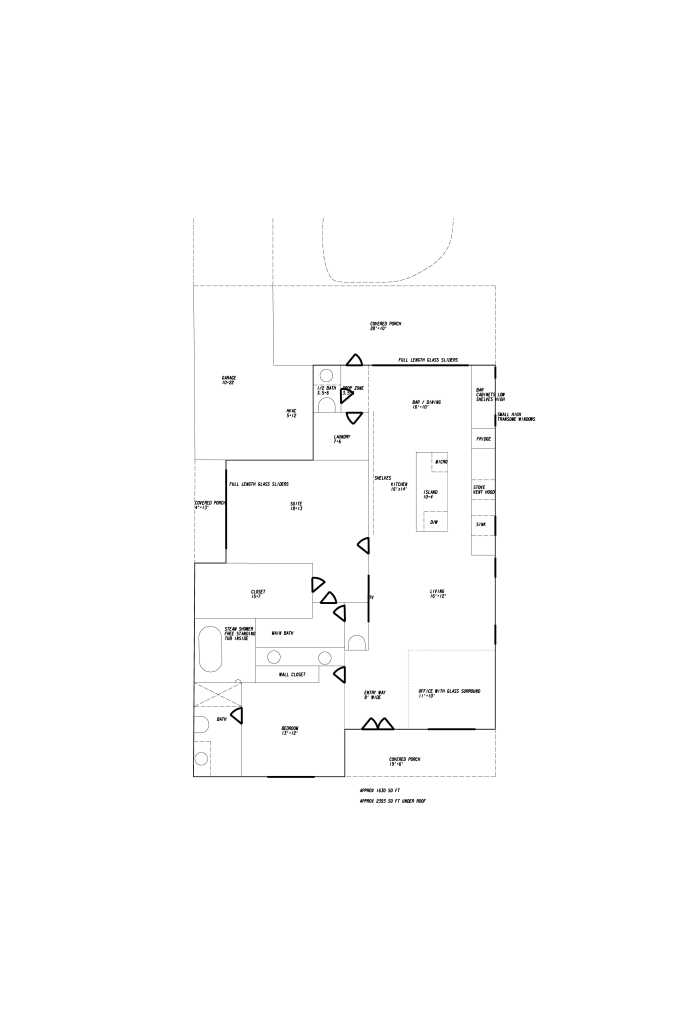
A huge front porch welcomes you home to this house. The front door opens into a two-story foyer with loads of windows wrapping the corner. The left side of the foyer features a half bath and coat closet.
On the left side of the front of the house sits a home office with French doors leading to the front porch and a wall of doors opening up to the main living area.
The main living area sprawls with a giant kitchen featuring a 10 foot island and a bar with pass-through leading to the massive 29′ x 12′ screened porch. Opposite sits a great room with 18′ accordion sliding doors out to the porch.
Up the stairs sits a decent sized loft and openings for linen closet, laundry room, hall bath, and two secondary bedrooms.
The primary bedroom sits at 14′ x 17′ and direct access to a private upper porch. The massive primary bathroom features a large soaking tub, 10′ x 4′ shower, and double sinks. It also leads to a giant 17′ long closet.
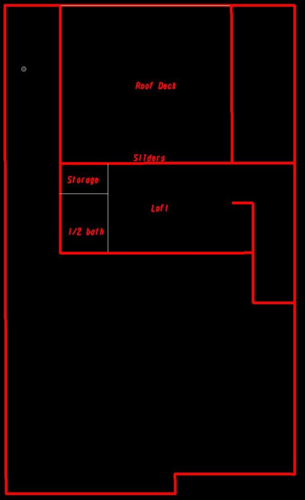
The third floor features a sizeable loft and 17’x16′ roof deck perfect for a hot tub.
The house totals around 2600 square feet with 3 bedrooms, two half baths, an office, and two loft spaces. The total footprint measures 29′ x 55′ making it a great fit for a variety of lots and leaves open for the possibility of a front garage, back garage, or alley entry garage based on lot specifics.
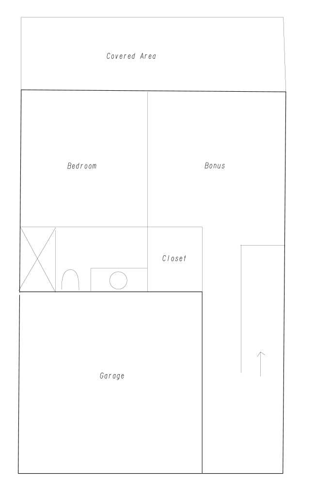
This three-story house features 2900 square feet of heated space. It has 3 bedrooms, 3.5 bathrooms, a bonus room, rooftop deck, and an office.
On the entry level is the entrance, garage, first bedroom, bonus room, closet and full bath perfect for guests.
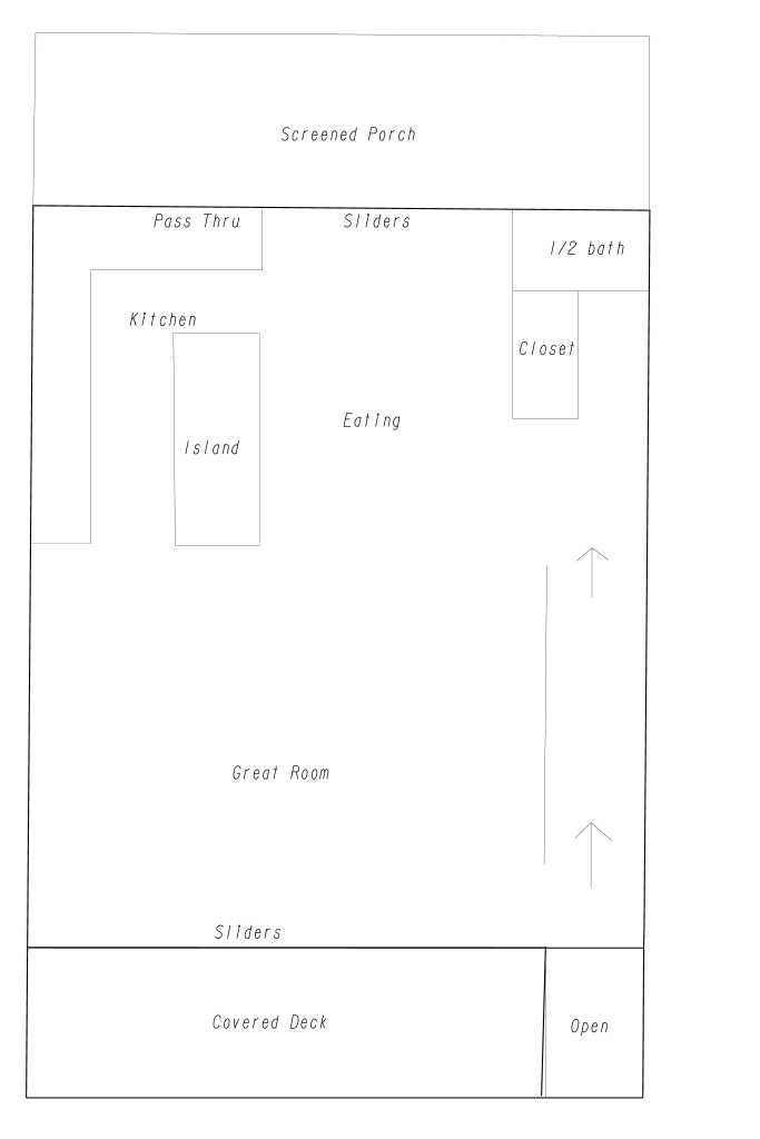
The main level spans roughly 1000′ square feet with a massive 24’x18′ Great Room with sliding acaridan doors to the front deck. The large large kitchen features an island and bar pass through to the screened porch and eating area. Tucked to the side are a closet and half bath.
The third level features the Primary Bedroom, a large bathroom with walk-in shower and embedded tub, huge closet, laundry and an additional bedroom and bath. The steal of the show though is the massive roof deck with overlooking office screaming for a hot tub.
This 1815 Square Foot 29’wide house features main level living with a partial second story. The house has a total of 2 or 3 bedrooms, 2.5 bathrooms and a dedicated office.
This 1815 Square Foot 29’wide house features main level living with a partial second story. The house has a total of 2 or 3 bedrooms, 2.5 bathrooms and a dedicated office.
I-40 through Research Triangle Park (RTP) between NC 147 (Future I-885) and I-540 is the busiest stretch of road within the state of North Carolina. According to the NCDOT, nearly 200,000 vehicles per day utilize I-40 just west of the I-540 interchange. There are also five busy interchanges within a three mile stretch leading to dangerous weaving, merge, and diverge movements. The implementation of local lanes on this stretch of I-40 would greatly enhance safety and ease of navigation through the busiest area of the Triangle.
The interchanges in question and gore to gore distances are as followed:
GoogleEarth
Exit 279 / NC 147 / Durham Freeway
.46 miles
Exit 280 / Davis Dr / RTP
.45 miles
Exit 281 / Miami Blvd
.25 miles
Exit 282 / Page Rd
.37 miles
Exit 283 / I-540
My proposed solution involves a local lane / collector-distributor (CD) lane hybrid system similar to the one on I-95 in Arlington, VA.
GoogleEarth
Vehicles traveling Eastbound on I-40 would split just West of Exit 279. Vehicles wishing to use Exits 279, 280, 281, and 282 would use the right lanes to enter the local lanes and proceed to their exits per usual. The left lanes would enjoy uninterrupted flow with the exception of the NC 147 SB On Ramp.
Vehicles traveling Westbound on I-40 would split just West of Exit 283. Vehicles wishing to use Exits 283, 282, 281, 280, and 279-A would use the right lanes to enter the local lanes and proceed to their exits per usual. The left lanes would enjoy uninterrupted flow with the exception of the NC 147 NB Off Ramp.
To ensure smooth tie-ins, an auxiliary lane would be added on I-40 from NC 147 to NC 54 (Exit 273) and on I-540 to Lumley Rd (Exit 3).
The conceptual sketches follow.
Conceptual Sketches – click to enlarge
The implementation of local lanes on this stretch of I-40 would greatly enhance safety and ease of navigation through the busiest area of the Triangle.