Phil Veasley is a Professional Engineer working to design safer multimodal infrastructure in cities throughout the US.
My goal is to create cities that are safe and effective for all people to move about outside of cars. To achieve that we have to focus on creating equitable, dense, and vibrant cities full of walkable neighborhoods with a various mix of housing choices, schools, restaurants, and services. We cannot have safe multimodal infrastructure without the density to support it and we cannot have equitable density without safe multimodal infrastructure. Outside of designing safe streets, my passions are sketching ideas for infill neighborhoods, floor plans, urban photography, and exploring our cities on foot or bike. Please check out the menus above for all of my ideas and also check out my YouTube, Instagram, and Twitter accounts.
Opinions and insights are my own and are not representative of my employer or any organization.
Welcome to September! The 8PM sunsets may be leaving until Spring, but it’s getting comfortable to be outside more. Fair trade, I say.
The Urban Connector monthly newsletter looks back on the best of the previous month as well as ways to get involved in the coming month. Please make sure you sign up below to have these delivered straight to your inbox and follow on YouTube,Twitter, and Instagram.
Part oneof a series exploring some of the highlights (and lowlights) of notable suburbs through the region. Stay tuned as many more are queued up for the coming months.
The former hospital site presents an unique opportunity to develop of cohesive connection between Downtown and the Beltline. There are some pretty impressive concepts floating around social media that depict a mixed-use village and complete streets, which would be great!
Site in relation to Downtown and the Beltline – GoogleEarth
Downtown Raleigh’s State of Downtown Report
Downtown Raleigh Alliance released the annual State of Downtown Report recently and shared this awesome photo of upcoming projects.
The booming Howell Mill corridor could be getting a 42-story tower soon. For reference, that’s taller than any building in Raleigh’s skyline and nearly half as tall as the biggest towers in Atlanta.
Smoky Hollow Park Funding
In what could be a true urban feeling city park, the City of Raleigh has received $8.7 million from the feds. Now if only, City Council had approved the tower to overlook the park to give more residents direct access.
Murphy Crossing
We’re getting closer to the much-anticipated Murphy Crossing development happening. This one could potentially change the game as far as how dense infill is done in the City.
What I’m working on this month(and probably later)
Updates to earlier drawings to the Reconnecting Communities sketches
The Enigma of North Hills video
Atlanta Summer 4K Drone Tour
I’m sure this newsletter will evolve as time goes on. Comments or suggestions? Let me know!
Phil Veasley is a Professional Engineer working to design safer multimodal infrastructure in cities throughout the US.
My goal is to create cities that are safe and effective for all people to move about outside of cars. To achieve that we have to focus on creating equitable, dense, and vibrant cities full of walkable neighborhoods with a various mix of housing choices, schools, restaurants, and services. We cannot have safe multimodal infrastructure without the density to support it and we cannot have equitable density without safe multimodal infrastructure. Outside of designing safe streets, my passions are sketching ideas for infill neighborhoods, floor plans, urban photography, and exploring our cities on foot or bike. Please check out the menus above for all of my ideas and also check out my YouTube, Instagram, and Twitter accounts.
Opinions and insights are my own and are not representative of any organization.
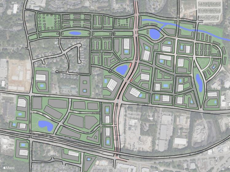
The Chapel Hill Rd station provides a huge opportunity to create a walkable mixed-use district in close proximity to the PNC Arena / Carter-Finley Stadium complex.
Today, the area is a mix of mixed density office / industrial, medical, arts and emptiness – really a hodgepodge of a lot of things.
GoogleEarth
In the future, complete district is possible containing apartments, condos, shopping, dining, park space, commercial, office, medical, and industrial space all within walking distance of three BRT stations.
NOTE: I do not own, control, have actual say, etc over any of the proposed redeveloped parcels. This is just an idea and just a sketch.
Stay tuned over the coming months as we’ll work through all of the stations along the corridor.
Phil Veasley is a Professional Engineer working to design safer multimodal infrastructure in cities throughout the US.
My goal is to create cities that are safe and effective for all people to move about outside of cars. To achieve that we have to focus on creating equitable, dense, and vibrant cities full of walkable neighborhoods with a various mix of housing choices, schools, restaurants, and services. We cannot have safe multimodal infrastructure without the density to support it and we cannot have equitable density without safe multimodal infrastructure. Outside of designing safe streets, my passions are sketching ideas for infill neighborhoods, floor plans, urban photography, and exploring our cities on foot or bike. Please check out the menus above for all of my ideas and also check out my YouTube, Instagram, and Twitter accounts.
Opinions and insights are my own and are not representative of my employer or any organization.
This new series will explore some of the suburbs that are getting (at least some) things right! First up, Woodstock. The small city is located roughly 30 miles North of Atlanta and is home to some of the most hellacious commute times in the Atlanta metro. Outside of an Express Bus and pricey express lanes, the car is king and your only option if you need to commute.
Woodstock in relation to Metro Atlanta
This doesn’t stop them from having one of the best suburban town centers around. Years of thoughtful infill around their historic core has led to a vibrant mix of shops, varied housing types, restaurants, parks, trails and more.
1993200220142024 – Images via GoogleEarth
I recently took some time on a quiet weekday morning to explore the scenery. There is a really good mix and variation of building scales and types which makes it feel like a much larger place. One initial drawback I noticed were the sheer amount of “Private Property” signs on seemingly accessible greenspace.
Phil Veasley is a Professional Engineer workingto design safer multimodal infrastructure in cities throughout the US.
My goal is to create cities that are safe and effective for all people to move about outside of cars. To achieve that we have to focus on creating equitable, dense, and vibrant cities full of walkable neighborhoods with a various mix of housing choices, schools, restaurants, and services. We cannot have safe multimodal infrastructure without the density to support it and we cannot have equitable density without safe multimodal infrastructure. Outside of designing safe streets, my passions are sketching ideas for infill neighborhoods, floor plans, urban photography, and exploring our cities on foot or bike. Please check out the menus above for all of my ideas and also check out my YouTube, Instagram, and Twitter accounts.
Opinions and insights are my own and are not representative of my employer or any organization.
Phil Veasley is a Professional Engineer working to design safer multimodal infrastructure in cities throughout the US.
My goal is to create cities that are safe and effective for all people to move about outside of cars. To achieve that we have to focus on creating equitable, dense, and vibrant cities full of walkable neighborhoods with a various mix of housing choices, schools, restaurants, and services. We cannot have safe multimodal infrastructure without the density to support it and we cannot have equitable density without safe multimodal infrastructure. Outside of designing safe streets, my passions are sketching ideas for infill neighborhoods, floor plans, urban photography, and exploring our cities on foot or bike. Please check out the menus above for all of my ideas and also check out my YouTube, Instagram, and Twitter accounts.
Opinions and insights are my own and are not representative of my employer or any organization.
August is here, I hope everyone is staying safe and dry at the coast! The Urban Connector monthly newsletter looks back on the best of the previous month as well as ways to get involved in the coming month.
Please make sure you sign up below to have these delivered straight to your inbox and follow on YouTube,Twitter, and Instagram.
Atlanta is a biking City. And it’s getting safer to get around. Check out my thoughts from a ride around the “Bowl.”
Developments that Excited Me
Memorial Drive Cycle Track – GDOT is adding a protected two-way cycle track connecting Downtown Atlanta to (just about) the Beltline along Memorial Drive! The project is nearing completion with most of the concrete curbs going in. Unfortunately many of them have already taken a beating from bad drivers but things should get better once vertical protection is also added. This one is absolutely a game-changer for getting around the area. GDOT deserves credit here.
Time will tell but there’s a new proposal to revamp the Mall at West End. I’ll file this under “I’ll believe it when I see it”, but it would be a massive deal for area residents and AUC students in a transit rich but service deficit area.
AMTRAK Downtown Hub?!
That dream isn’t dead yet. Hopefully they’re in negotiations with Centennial Yards before it’s too late to have a spot along the rails for a platform.
More of a bittersweet moment, but Friday was my last day with Toole Design Group. My time there was nothing short of amazing. I learned not only how to be a better Engineer but also how much work we have to do in improving infrastructure to be accessible to people outside of the car.
I’m sure this newsletter will evolve as time goes on. Comments or suggestions? Let me know!
Phil Veasley is a Professional Engineer working to design safer multimodal infrastructure in cities throughout the US.
My goal is to create cities that are safe and effective for all people to move about outside of cars. To achieve that we have to focus on creating equitable, dense, and vibrant cities full of walkable neighborhoods with a various mix of housing choices, schools, restaurants, and services. We cannot have safe multimodal infrastructure without the density to support it and we cannot have equitable density without safe multimodal infrastructure. Outside of designing safe streets, my passions are sketching ideas for infill neighborhoods, floor plans, urban photography, and exploring our cities on foot or bike. Please check out the menus above for all of my ideas and also check out my YouTube, Instagram, and Twitter accounts.
Opinions and insights are my own and are not representative of any organization.
Subscribe to receive email notifications for new articles.
Sights and insights from a great right along the “bowl” of the existing, interim, and future Beltline and Westside Park.
Bill Kennedy Way to Boulevard
So much time is going to be saved through Southeast Atlanta once the Beltline is open through here next year. Right now, most of these roads feel fine to ride on with an E-Bike but those hills are massive.
Boulevard to Downtown Connector
The gravel South trail is still “open” despite the signs. There hasn’t been any sign of dirt movement just yet. It’s a pretty surreal feeling through here that feels more like the middle of nowhere or a private oasis than being two miles outside a major Downtown. It’s also pretty disappointing how some recent developments such as the Beacon, Pratt Stacks and others did nothing to engage the trail knowing what was coming. Some of the features and tunnels going through this section are unmatched. With the 1000s of units on the way in this area, it’s going to be a cool vibe in a few years. Some of the more recent builds along Milton Ave are already doing a good job engaging the trail. It’ll be interesting to see how the Pryor safe street project ties into the trail.
Downtown Connector to Westside Park
Back onto pavement as we pass the Downtown Connector brings us past Pittsburg Yards which is not much more than one building and massive blocks of opportunity to date. Really big opportunity to get some more housing. The Vivian turned out nice for being the first trail oriented complexes outside of the Eastside. The infrastructure surrounding the bridges also paints the picture of how much forethought into Beltline rail has gone into the original trail designs. So much housing is coming in the next few years around Murphy Crossing but we need much more near Lee + White. Does anyone know the backstory around the weird on-street detour between Lawton and RDA? Getting past the in-progress section between Washington Park and Bankhead wasn’t too challenging on some neighborhood streets. Speaking of Bankhead, the “road diet” which was a 4-to-3 conversion with insanely wide lanes is finally complete. Hopefully Microsoft either sells or continues with their plan because we can’t just have this much valuable land sitting vacant. It’s essentially a blank slate to provide dense, sustainable and mobility rich housing.
Westside Park to Downtown
Westside Park is a prime example of why I don’t put much stock into the acreage of a park being it’s selling point. It is still pretty dope though. Heading back down Proctor Creek passes perhaps my favorite spot in the city with a rocky shoals and winding trail bridge that feels more like a mountain setting. There’s a flagrant gap in access adjacent to the failed Microsoft and Quarry Yards campus between the Westside Connector and Proctor Creek Greenway which will fill a massive void once complete. Heading down the Westside Connector sees tons of infill opportunities which is jarring being this close to Downtown. It does seem like Echo Street is struggling a bit to fill their trail fronting parts but in time it will come. Getting closer to GWCC sees a multi-use trail that you may not realize is usable until you’re on it and actually provides a few grade separations around the stadium. I talk about it often, but the impact of Centennial Yards and South Downtown are going to absolutely transform the core of our City. I believe a City is only as strong as it’s core.
It hasn’t been long, but it’s hard to even imagine getting around outside of the car now without the MLK and Memorial cycle tracks. Little by little, we’re building a City where it’s safe to get around without a car.
Phil Veasley is a Professional Engineer workingto design safer multimodal infrastructure in cities throughout the US.
My goal is to create cities that are safe and effective for all people to move about outside of cars. To achieve that we have to focus on creating equitable, dense, and vibrant cities full of walkable neighborhoods with a various mix of housing choices, schools, restaurants, and services. We cannot have safe multimodal infrastructure without the density to support it and we cannot have equitable density without safe multimodal infrastructure. Outside of designing safe streets, my passions are sketching ideas for infill neighborhoods, floor plans, urban photography, and exploring our cities on foot or bike. Please check out the menus above for all of my ideas and also check out my YouTube, Instagram, and Twitter accounts.
Opinions and insights are my own and are not representative of my employer or any organization.
The Chapel Hill Rd station provides a huge opportunity to create a walkable mixed-use district in close proximity to the PNC Arena / Carter-Finley Stadium complex.
Today, the area is a mix of low-density industrial, forest land, and a huge surface / staging lot.
GoogleEarth
In the future, complete district is possible which would provide a village like district of apartments, condos, townhomes, single family cottages, shopping, dining, park space, commercial, office, and industrial space all within walking distance of the BRT station.
NOTE: I do not own, control, have actual say, etc over any of the proposed redeveloped parcels. This is just an idea and just a sketch.
Stay tuned over the coming months as we’ll work through all of the stations along the corridor.
Phil Veasley is a Professional Engineer working with Toole Design Groupto design safer multimodal infrastructure in cities throughout the US.
My goal is to create cities that are safe and effective for all people to move about outside of cars. To achieve that we have to focus on creating equitable, dense, and vibrant cities full of walkable neighborhoods with a various mix of housing choices, schools, restaurants, and services. We cannot have safe multimodal infrastructure without the density to support it and we cannot have equitable density without safe multimodal infrastructure. Outside of designing safe streets, my passions are sketching ideas for infill neighborhoods, floor plans, urban photography, and exploring our cities on foot or bike. Please check out the menus above for all of my ideas and also check out my YouTube, Instagram, and Twitter accounts.
Opinions and insights are my own and are not representative of my employer or any organization.